
A trip from Fredericton to Oromocto via the Lincoln Trail and Burton Bridge.
| Location | Type of Route | Distance | Days | % Unpaved | Total Ascent |
| Fredericton | Gravel/Road | 44.8 km | 1 | 30% | 173 m |
OVERVIEW:
This popular route provides panoramic views and exposure to the beautiful St John River as well as a picturesque bridge crossing and journey along the Oromocto River. The largely flat route follows the trails across the Bill Thorpe Walking Bridge and along the Lincoln Trail, with an option to use the road to bypass the airport. In Oromocto there is an opportunity to picnic beside the river or visit one of the many establishments in the adjacent mall. Following a lunch, a short trip brings you to the Burton Bridge, which provides a spectacular view of the St. John River. The route up the north side of the river is along the main road with paved shoulders, and there are several opportunities to enjoy market stands and ice cream.
ABOUT OUR TRIP:
Yet another beautiful day and we stuck with the free parking strategy by starting at the Trail Visitor Center on the Northside where we set o south, over the walking bridge onto the beautiful Lincoln Trail where we then headed east to Oromocto for our picnic lunch.
What a gorgeous trail this is, and some of the gardens that you pass by are truly remarkable. There is plenty of shade and it is easy going on the crusher dust. The trail shadows highway 102 and criss-crosses over a few times.
Where it crosses the road at Lincoln there’s a shop for refreshments and a water supply a short distance further along the trail just in case you change your mind about grabbing a drink.
This might be a good time to mention that if you have a road bike and you find nursing your bike on the less than gentle sections tedious, then it might be an idea to cut out the section of trail that takes you around the back of the airport.
When we reached Nevers Road some of our group turned left and headed down that road until they hit highway 102 where they turned right and kept going until they got to route 655 and head up the Waasis Road until they rejoined the Lincoln trail again. It is not that the trail is for mountain bikes, but they are better suited than some of the more delicate roadsters.
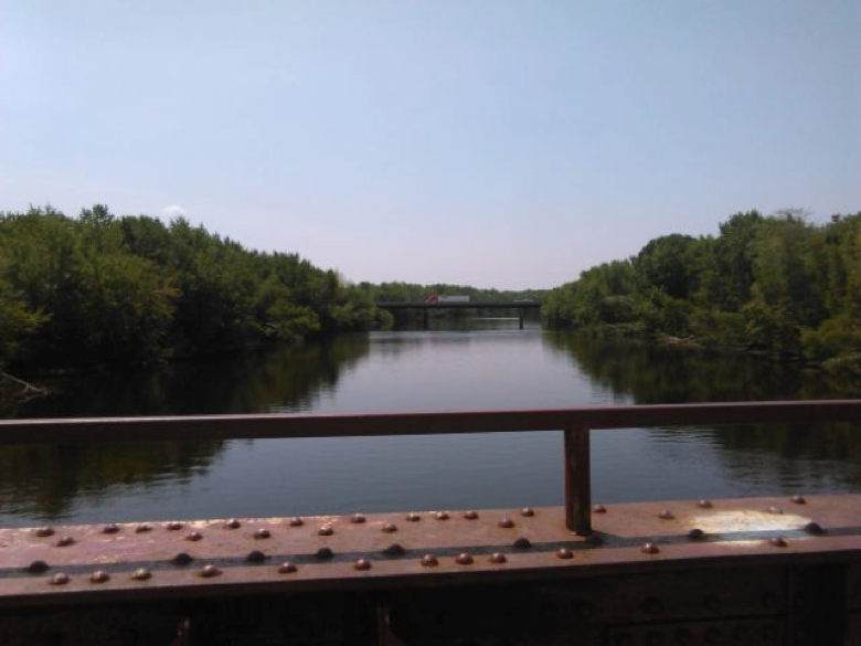
It is not much further along the Lincoln trail that you cross the water over the old railway bridge where it is a most pretty sight and worth a stop to take in the view.
Shortly after that we went through the underpass of highway 102 into Oromocto and the recreation area of Sir Douglas Hazen Park. What a gorgeous place for a picnic, right beside the marina and with shops close at hand for those who preferred something more substantial to eat and drink.
After lunch our group split up. Some returned the way they came and who could blame them. It was such a pretty and tranquil trail and the rest of us continued on to Burton Bridge to make a loop and return on the north side of the river.
At the end of Sir Douglas Hazen Park we turned right onto Onondaga St and then left onto MacDonald Avenue which brought us to Waasis Road where we turned left towards Burton. Follow the signs for highway 105 and turn left over the bridge that crosses the St. John River.
Burton Bridge is quite a climb and takes away the some of the enjoyment of the view. There is no cycle lane and just a narrow high footpath to the side. But putting the precariousness to one side, the view is just amazing!
Follow the road signs for 105 North to Fredericton. is road follows the river and all but takes you straight back to your car at the Trail Visitors Center.
The 105 is an excellent paved road with nice sized cycle lanes and wonderful opportunities to sample the local delicacies (… like ice creams!) at both the Big Potato and the Country Pumpkin.
When you get back to Fredericton, at the Princess Margaret Bridge make sure to follow the signs for Highway 105-Fredericton Center to avoid going over the bridge; where it then brings you to a set of lights follow highway 105 North (straight on) where eventually (keep going straight over the different sets of lights) Station road is on your right immediately after you go under the underpass bringing you back to where you left your car.